 Return to the PREVIOUS PAGE
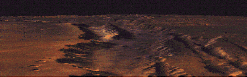
Objective: To develop a distributed, interactive scientific visualization system for exploration of very large earth and planetary databases. The solutions pursued are to develop an efficient and scalable parallel 3-D perspective rendering program on the parallel supercomputer and a real-time interactive navigation and viewing system using the high-speed network.
Approach: The ray-identification algorithm is used for the parallel rendering on the parallel supercomputer. The algorithm employs a sinusoidal spherical data representation for global datasets. The parallelism is achieved by decomposing the input dataset into small equal-sized grids and distributing the grids randomly over the parallel processing elements. Various techniques have been developed to improve the scalability and the efficiency of the algorithm, including a distributed output data structure for scalable communication, a grid-based pre-screening and an input data pyramiding mechanism for efficient computation.
The parallel renderer interfaces with an SGI-based navigator GUI, called the Spaceflyer, and a 2-D map viewer via the Internet. The Space-flyer provides the renderer the current view-points and the 2-D map viewer displays the observer's current location. The high-resolution rendered images are computed by the parallel renderer on the fly and sent back via the gigabit network to display on a HiPPI framebuffer. Accomplishments: In FY ╘94, the parallel ray-identification algorithm has been developed and implemented on the Intel Touchstone DELTA, the Intel Paragon, and the Cray T3D MPP machines. Two earth and planetary datasets have been assembled to test and demonstrate the program. The first one is a 650 Mbyte California Mojave desert dataset at 30-meter resolution constructed from LANDSAT data coregistered with the USGS digital terrain model. The second one is a 1.3 Gbyte global color mosaic of Mars recently assembled by USGS and the PDS Mars digital terrain model at 1/64 degree resolution.
A prototype interactive visualization system using the parallel ray-identification renderer, the Hippi network, and the Spaceflyer navigator GUI has been built this year. This visualization system with the Mojave desert dataset has been demonstrated in real-time on a 128 node Intel Paragon at Supercomputing '93 at Portland, Oregon. The same system running on the JPL Cray T3D has been shown at the JPL Cray T3D dedication ceremony, January '94. The system was used by a separate Code S project to create a four minute animation movie "Interactive Science Data Analysis Using Parallel Super-computers", featuring the 3D rendering over the USGS global Mars dataset. It was rendered entirely on the JPL Cray T3D and the Caltech Intel Paragon.
Significance: Although workstation-based hardware renderers have been created with very good interactive performance, they are limited in the size of the image base that can be considered at any one time and the hardware process introduces artifacts into the final images. With the introduction of scalable software renderers, interactive exploration of very large databases both for exposition. and for scientific purposes becomes possible.
Status/Plans: The software is ready for delivery to the HPCC Software Exchange. We plan to build a more robust user interface to the renderer and introduce key new features enabling interactive scientific processing and its visualization. Multiresolution, multispectrum and -temporal datasets will be included as well as the introduction of volume rendering to handle 3-D volume datasets generated by numerical simulation models.
Point of Contact:
Return to the PREVIOUS PAGE