NASA Research and Education Network
FY97 Annual Report

"Enabling revolutionary applications by accelerating networking technology development for aeronautics and space"
Christine Falsetti, NREN Project Manager
Bessie Whitaker, Deputy NREN Project Manager
2. TECHNICAL OVERVIEW and ACCOMPLISHMENTS
2.1 NASA RESEARCH AND EDUCATION NETWORK/NEXT GENERATION INTERNET (NREN/NGI)
2.2 TELEMEDICINE (ECHOCARDIOGRAPHY)
2.3 ADVANCED AEROSPACE DESIGN (ADTE/DARWIN)
2.4 DISTRIBUTED IMAGE SPREADSHEET - EARTH OBSERVING SYSTEM
2.5 VIRTUAL SIMULATION LABORATORY
3. NREN Accomplishments reported under the Earth and Space Sciences (ESS) Project
NREN Vision:
Aerospace engineers will revolutionize air travel by remotely controlling wind tunnels on their desktops, astronauts and engineers will train together in realistic simulations of space flight, medical researchers will safely monitor and treat humans in space from the Earth, Earth scientists from all over the country will develop climate models that allow us to predict and respond to environmental events such as floods, and space scientists will chart the evolution of the universe. The NREN Brochure provides a complete overview of the NREN Project. Note: You will need to use your back button on your browser to return to this report.
2. TECHNICAL OVERVIEW and ACCOMPLISHMENTS
This is an overview of the accomplishments of the NASA Research and Education Network/Next Generation Internet (NREN/NGI). Summary details follow for each Application, these summaries contain information about the application, the objectives, approach used, the accomplishments, the significance, the status and plans, and points of contact and any relevant url's follow.
2.1 NASA Research and Education Network/Next Generation Internet (NREN/NGI)
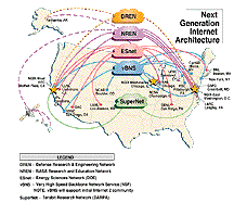
NREN will interconnect to the Next Generation
Internet at the "NGI eXchanges" --NGIXs-- to
expand research community participation and
address networking scaling.
2.1.1 Objectives
- To create high performance networks to enhance networking capability among scientists, industry, and academia to meet certain mission objectives,
- To connect research universities and national labs with high performance networks,
- To promote experimentation with the next generation of networking technologies, and
- To demonstrate new applications that meet important national goals and missions.
2.1.2 Approach
- Demonstrate 100 times end-to-end performance improvement for five applications based on FY 1996 performance measurements across NASA/NREN testbeds over the 155 Mbps wide area network.
- Establish next generation internetwork exchanges for NASA to connect Grand Challenge universities principal investigators to NASA high performance resources.
- Act as a catalyst in the integration and commercialization of advanced high-performance networking technologies.
2.1.3 Accomplishments
1993
06/93 Interconnected to NSFnet at 45 Mbps.
1994
09/94 Demonstrated T-3 (45 Mbps) Level 3 HPCC interconnects.
1995
06/95 Demonstrated satellite-based gigabit applications using the Advanced Communications Technology Satellite (ACTS) and associated ground terminals.
09/95 Demonstrated 155 Mbps NREN interconnects.
1996
03/96 Demonstrated interoperability between independently managed NREN networks that are based on ATM technology supplied by multiple vendors.
11/96 Restructured NREN project and management to better align with HPCC Program objectives. Organization and management structure of NREN was established and supported by Centers and HQ.
12/96 Moved beyond the single dimension of speed to 3-D networking (capacity, capability, and applications) in response to NASA mission applications requirements.
1997
02/97 Designed NREN to scale to the demands of the Next Generation Internet.
05/97 Partnered with NASA's research community to identify 14 advanced applications requiring advanced networking performance, 6 of which were identified and proposed to NGI as applications to benefit the larger research community.
NGI accepted the following: three applications from Mission to Planet Earth (NASA Instrument Quality Assurance, Instrument Support Terminal, and Distributed Image SpreadSheet), two from Advanced Aerospace Design (Collaborative Simulation and Virtual Simulation), and one from Telemedicine (NASA Echocardiography)
06/97 Established a baseline that demonstrated:
- that NASA's current production network does not have the capability to support advanced applications being developed for the research community, and
- the need for strong partnerships with other agencies, industry, and academia to develop advanced tools that can meet and exceed the networking challenges presented today and in the future.
06/97 Organized a West Coast NGI Industry Briefing to bring together government and industry to initiate collaboration and cooperation to create the Next Generation Internet.
06/97 Finalized a Memorandum of Understanding with the NASA Integrated Services Network (NISN) that allows for a more aggressive process to transfer new technologies to a production environment for the customer base.
07/97 Established an interagency agreement to develop three NGI exchanges, one on the West Coast (Ames), one in the midwest (Chicago), and one on the East Coast (D.C.). Developed an interoperable architectural model for the East and West Coast exchanges with the Department of Energy and Lawrence Berkeley Laboratories.
08/97 Established and will continue to establish collaborative agreements with industry and academia via the Ames Commercial Technology Office. Initiated technology partnership program with industry under the Next Generation Internet Program. Signed partnership agreements with Cisco Systems and Fore; additional agreements are under development.
09/97 Demonstrated 100 times increase in performance over the current operational capabilities for five advanced applications in FY97: (Online Summaries of Applications)
09/97 Organized an East Coast NGI Industry Briefing to bring together government and industry to initiate collaboration and cooperation to create the Next Generation Internet. NREN Project Manager served as Keynote speaker.
09/97 Held the second NREN Applications workshop, September 15-18, that identified new advanced applications to support critical NASA missions and identified current limitations and challenges of the NASA's operations network.
09/97 Installed Sprint POP at NASA Ames Research Center providing OC-12 service to NASA ARC.
2.1.4 Significance
NREN's ability to research, prototype, and develop advanced networking capabilities for the agency enables the success of many NASA key missions. Partnering with other agencies, industry, and academia leverages more cost- and time-effective mechanisms to develop and transition advanced network capabilities to the entire Internet community.
NREN is an active participant in the creation of the Next Generation Internet - it actively participated as lead organizer of the NGI Implementation Plan team, organized industry briefings, and negotiated agreement with interagency partners on three initial NGI Exchanges (NGIXs). As a direct result of the industry briefings, the Ames Commercialization Office has established and will continue to establish collaborative agreements with industry and academia.
2.1.5 Status/Plans
NASA's role in high performance networking is to establish an advanced network testbed for prototype demonstrations by the NASA mission and application community while at the same time guiding commercial infrastructure development for NASA and the nation. Currently, NASA's NREN applications partners include Advanced Aerospace Design, Astrobiology, Astrophysics, Earth Sciences, Space Exploration, and Telemedicine. Future application demonstrations are planned to explore advanced applications in the areas of 3-D collaboration, digital libraries, distributed computing, image processing, scientific visualization, simulation, and virtual environments.
NREN is partnering with industry, academia and federal agencies from program inception to deliver an application-enabled network testbed today. The testbed will complement industry efforts by demonstrating new network capabilities that address application challenges. It will focus on networking and communications innovations, and the results will be readily transferred to commercial providers and the NASA Integrated Services Network (NISN).
2.1.6 Key Milestones

2.1.7 Points of Contact and Relevant URLs:
Christine Falsetti, NREN Project Manager, NASA Ames Research Center, 650-604-6935
Bessie Whitaker, NREN Deputy Project Manager, NASA Ames Research Center, 650-604-6125
NASA Research and Education Network
Next Generation Internet (NGI) Initiative
2.2 Telemedicine (Echocardiography)
2.2.1 Objectives
- Enrich life on Earth through the application of telecommunications, computer, and microelectronic and nanoelectronic technologies to support revolutionary improvements in health care delivery to the global community.
- Promote the development and use of advanced technology for the delivery of health care which will benefit spaceflight and enhance health care for all humanity.
- Develop and implement necessary medical care systems to support human space flight.
- Develop, test, and evaluate integrated telecommunications/computer/space technologies to provide critical health care services to US and international space missions.
- Develop ground-based activities for definition and testing of emerging technologies in computer hardware, software, and ancillary tools in medical care.
- Transfer information technologies to organizations that collaborate with NASA to provide them the institutional, technological, and programmatic capacities to support health care activities critical to US and international space missions.
2.2.2 Approach
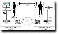
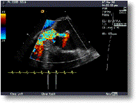
Echocardiographic images were transmitted between an expert observer at Ames Research Center (ARC) and a cardiologist and sonographer at Lewis Research Center (LeRC). Images were obtained from a variety of patients and normal volunteers. The compression ratio and channel quality of service was unknown to the remote observer who reported qualitative interpretations of the images and quantitative data measured off the screen. The demonstration also tested how well the sonographer could be guided to nonstandard views by the remote observer, testing both image quality and the impact of network performance, jitter, and delay.
The demonstration tested the real-time transmission and interactive guidance of Echocardiography (EC) utilizing bandwidths between 1.544 and 10 Mbps. It required an ATM virtual circuit with a capacity of up to 15 Mbps of user data. Packet loss probability, and picture quality and jitter are key factors governing the clinical acceptability of the received image stream. The network was required to support high speed data transmission, low probability of error, minimal delay, and high reliability. In this demonstration, a mechanism for introducing controlled degradation into the link was required.
2.2.3 Accomplishments
NREN has completed work with LeRC on implementing echocardiography across NREN. Successful transmission was achieved on August 28, 1997, when a Cleveland Clinic Foundation (CCF) sonographer acquired images from a volunteer at LeRC using an ATL HDI3000 echo machine (to be launched to the Space Station in 2000). Video feed was encoded in MPEG (1 Mbps) and MPEG-2 (2 to 5 Mbps) and sent via NREN ATM to ARC. A CCF cardiologist at ARC interpreted the images and guided acquisition, while a CCF cardiologist at LeRC observed live images for comparison with remote diagnosis. Cell loss rate was 10-9 to 10-3, and cell error rate was 10-9 to 10-3.
2.2.4 Significance
This demonstration represents a collaboration between the NASA's LeRC, ARC, Johnson Space Center (JSC), and the Cardiovascular Imaging Center of the CCF. It will promote knowledge and technologies that promise to enhance our health and life on Earth, foster global access to health care information and education, and be applicable to future space missions such as the International Space Station.
2.2.5 Status/Plans
Demonstrations were performed August 25-28, 1997. Results of this application will provide a mechanism for real-time guidance of cardiac, musculoskeletal, and peripheral vascular ultrasound aboard the International Space Station and on future lunar and planetary missions.
2.2.6 Points of Contact and Relevant URLs:
John Griffin, NREN Applications Manager, NASA Ames Research Center, 650-604-5447
Real-Time, Interactive Echocardiography Over Wide Area Networks
2.3 Advanced Aerospace Design (ADTE/Darwin)
2.3.1 Objectives
The objectives of advanced aerospace design are to revolutionize the aviation industry by elevating the power of computing tools through fuzzy logic, artificial intelligence and networking systems, and by integrating multidisciplinary product teams, linking design, operations, and training databases to dramatically cut design cycle times.
2.3.2 Approach
The Ames Aeronautics Design and Test Environment (ADTE) group will use NREN's high-speed network to support an integrated development environment for the aerospace industry using the Darwin computer tool. Applications planned include remote control of wind tunnel experiments, demand access to experimental and computational data sets, interactive/collaborative visualization, distributed computing, and teleconferencing. Data will flow bi-directionally between Ames, Boeing, and McDonnell Douglas using the NREN high-speed/high-bandwidth infrastructure. Virtual and Remote Wind Tunnel tests are expected to run from July 1997 through July 1998 and possibly beyond.
2.3.3 Accomplishments
NREN established an interconnection to Boeing Seattle in July 1997. The first phase of the project involved virtual wind tunnel simulations and tests of remote access between Ames and Boeing, Seattle, WA. Visualization employed computational fluid dynamics (CFD) simulations in which the data were processed overnight and analyzed the next day. Use of CFD allows multiple-design runs as well as comparisons between numerical data and wind tunnel data. Boeing and McDonnell were able to access the data generated in near real time and interactively collaborated in the testing process.
The second phase of the project, to begin in fall 1997, will involve remote access from Boeing Seattle, and McDonnell Douglas in Huntington Beach, California, to tests running in the Ames 12-ft subsonic wind tunnel. Two developmental tests and three operational tests will be conducted.
2.3.4 Significance
ADTE is helping reduce the aerospace design cycle time by about 25 percent and is providing information access to cut the number of independent design cycles. Next-generation design tools are beginning to revolutionize the aviation industry. Research in information technology will elevate the power of computing tools through fuzzy logic, artificial intelligence, and networking systems. These tools will integrate multidisciplinary product teams, linking design, operations, and training databases to dramatically cut design cycle times.
2.3.5 Status/Plans
Network performance will be measured in relation to capacity (bandwidth), delay and end-to-end round trip, and reliability, including availability, error/loss rates and security. A set of requirements will be developed which will verify end-to-end levels of service. Results of the tests will help determine whether use of ATM is as good as wide area bandwidth for this type of collaborative computing. Another option may be the use of the synchronous optical network SONET.
2.3.6 Points of Contact and Relevant URLs
John Griffin, NREN Applications Manager, NASA Ames Research Center, 650-604-5447
Aeronautics Design/Test Environment (DARWIN)
2.4 Distributed Image SpreadSheet - Earth Observing System

(For more images try: Image Catalog)
2.4.1 Objectives
The objective is to provide users with tools to perform advanced visualizations of very large datasets by the use of Distributed Image SpreadSheets (DISS) to develop an understanding of the total Earth system and the effects of natural and human-induced changes on the global environment, and to expand scientific knowledge of the Earth system using NASA's unique capabilities from the vantage points of space, aircraft, and in situ platforms. The project seeks also to disseminate information about the Earth system, and to enable the productive use of Mission To Planet Earth (MTPE) science and technology in the public and private sectors.
2.4.2 Approach
The Distributed Image SpreadSheet is based on a high-performance compute engine and a user visualization terminal. DISS is a highly interactive visualization and analysis (visanalysis) tool which combines a traditional spreadsheet paradigm with image processing, scientific visualization, and data archiving functionality. DISS is a type of scalable visanalysis tool that is essential for scientists, enabling the analysis of the large amounts of hyper-image data produced by next generation satellite systems. NASA's contribution to Global Change Research is the Earth Observing System (EOS), which is expected to have a total data production of 1 to 2 TB/day.
DISS provides users with tools to perform advanced visualizations of very large datasets such as the organization and comparison of almost 12 years of Total Ozone Mapping Spectrometer (TOMS) data. Other sample data sets used to show the development and evaluation of the functionality of the DISS include NOAA Advanced Very High Resolution Radiometer, NOAA Geostationary Operational Environmental Satellite, Landsat Thematic Mapper, Special Sensor Microwave/Imager, Airborne Visible and Infrared Imaging Spectrometer, NEXRAD, P3 aircraft radar, and EOS assimilated numerical model data produced by Goddard's Data Assimilation Office.
2.4.3 Accomplishments
In June 1997 at the National Center for Atmospheric Research (NCAR) in Boulder, Colorado, DISS was demonstrated for the first time at the Global Observation Information Network (GOIN) workshop, a US-Japan bilateral demonstration of information networks. For this demonstration, the user client workstation (a remote visualization terminal operated at NCAR) accessed data remotely at GSFC (about 1500 miles away) from a high performance storage system via a high performance wide area network (WAN). The WAN connectivity included a NASA NREN connection at OC-3 rates to NCAR via a vBNS connection at San Diego Supercomputing Center at OC-12 rates, and Fiber Distributed Data Interface (FDDI) network interfaces for the server and client.
In September 1997 at NASA Ames Research Center in Moffett Field, California, DISS was demonstrated using Asynchronous Transfer Mode (ATM) end-to-end for the first time. An OC-3 connection using NREN's network via the Sprint ATM Cloud was established between GSFC and Ames for the NREN Workshop. Application performance of the DISS dramatically improved by a factor of ten using ATM end-to-end.
2.4.4 Significance
The Distributed Image SpreadSheet is an EOS application that is expected to be widely used by the EOS community. Distributed visanalysis and high-speed remote access to geophysical data archives via high performance networks is critical to the success of NASA's Mission to Planet Earth program. The DISS tool is also important to other agencies involved in data analysis and modeling for aeronautics, astrophysics, geophysical studies, environmental monitoring, and mapping.
2.4.5 Status/Plans
The Goddard Earth Science Data and Information System (ESDIS) project collaborates with the Ames NREN project for the purpose of prototyping EOS Data Information System (EOSDIS) applications. The DISS tool, combined with NREN connectivity, facilitates public and commercial use of meteorological datasets - broadcast weather services such as NBC WRC-TV already use NOAA's satellite imagery processed by NASA and are using this system on a daily basis.
2.4.6 Points of Contact and Relevant URLs
John Griffin, NREN Applications Manager, NASA Ames Research Center, 650-604-5447

2.5.1 Objective
To create a new approach to aeronautical research and development by providing a virtual simulation environment offering remote and interactive participation.
2.5.2 Approach
The Virtual Simulation Laboratory (VLAB) is developing the technology and methodology for remote access to a research facility employing an interactive, virtual reality interface. Emphasis is on the user's perspective - a virtual environment wherein the user interactively defines the specific data and display configuration. The design allows for multiple independent "players" at different remote sites, who can define their own custom displays.
The VLAB conducted a fully integrated operational test over NREN with the active participation in Space Shuttle landing simulations at Ames. The project required reliable, high speed, wide-area connectivity to support the client/server connection along with digital audio, MPEG-2, audio/video conferencing and whiteboarding. Aggregate bandwidth had to provide for delay of less than 0.5 seconds, transmission rates of 20 Mbps sustained/ 35 Mbps peak, and packet loss of less than 2 percent.
The first implementation of VLAB was a virtual interface to the Vertical Motion Simulator (VMS) at ARC, which specializes in the study of air and spacecraft handling characteristics, flight dynamics, flight controls and display systems. The VMS features a large amplitude motion system coupled with interchangeable cockpit systems to provide enhanced motion queuing and flexible cockpit configuration to support a wide variety of simulation research projects. NREN connected ARC and JSC via the Sprint ATM WAN, and FDDI LANs provided local connectivity to NREN.
2.5.3 Accomplishments
The VLAB Demonstrator Project completed a very successful run of tests, demonstrations, and productive engineering use at Johnson Space Center (JSC). For six weeks, VLAB provided continuous, highly interactive, remote access to the Space Shuttle simulation running on the VMS at ARC. The Principal Investigator (PI) extended the test an extra week, running the experiment from the remote site, and plans to run cases exclusively from JSC, thus allowing him to coordinate with independent, concurrent studies at JSC.
2.5.4 Significance
The technologies and methodologies employed will be applicable generally to remote access virtual laboratories and interoperable facilities, and will provide broad access to national facilities by U.S. industry. Costs will be significantly reduced by eliminating travel to test sites. The VLAB provides remote access from researchers' desktops to ARC simulation laboratories for interactive participation.
While this virtual laboratory prototype is specific to flight simulations in the VMS, the technologies and methodologies employed will be applicable more generally to remote access, virtual laboratories offering immersive environments, and interoperable facilities. VLAB will provide industry with inexpensive and convenient access to national simulation resources and will foster the concept of interoperability among national laboratories. It will enable industry to improve its design process yielding aeronautical products with a true competitive edge.
2.5.5 Status/Plans
All of the technical objectives for the project have been met and exceeded. Because of its nearly flawless performance, VLAB is now considered a legitimate engineering tool. All of the technical objectives for the project have been met, and the remote customer is now using the VLAB as an integral part of the simulation. A large number of people participated in demonstrations of VLAB, both at JSC and ARC, and there have been numerous suggestions for future applications. Phase 2, which will enhance the application, is now in development.
2.5.6 Points of Contact and Relevant URLs
John Griffin, NREN Applications Manager, NASA Ames Research Center, 650-604-5447
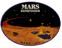
2.6 Virtual Reality on Mars Pathfinder
2.6.1 Objective
The purpose of the Mars Pathfinder Mission (MPF) was to demonstrate technology for future Mars exploration while performing scientific exploration of Ares Vallis, the site of an ancient flood. The chosen landing site had a wide variety of rock types in a relatively small area that the rover could cover to analyze the composition of the rocks.
2.6.2 Approach
NASA Ames supported MPF by providing a photo-realistic virtual reality model of the environment, called MarsMap. MarsMap is a 3-D interactive map that assisted with rover data archiving and operational planning. The primary wide area network (WAN) requirement for MPF was to provide a consistent, wide bandwidth data pipeline between the Jet Propulsion Laboratory (JPL) Mission Control and the Ames Intelligent Mechanisms Group. NREN provided this link via Sprint ATM. Raw image data from the stereo cameras on the Pathfinder lander were relayed from JPL to Ames upon receipt. At Ames, the data were processed to produce a virtual reality terrain model which was then sent back to JPL for display.
2.6.3 Accomplishments
Round trip data processing time was less than 15 minutes, based on the computational time to produce the models at Ames. Thus, the data link provided Pathfinder with the enhanced computational capability available at Ames in near real time. MPF was the first U.S. mission to Mars in 20 years, and is the first of a series of planned rover missions to that planet. The highly successful mission landed on Mars July 4, 1997. MPF begins a series of missions that will send orbiters, landers and rovers to the Martian surface in 1998, 2001, and 2003.
2.6.4 Significance
NREN involvement with Pathfinder demonstrates high speed WAN interoperability and collaborative capabilities between NASA field centers, industry and academia. Internet access to Mars images provides a preview of the next generation of planetary exploration and has kindled an intense interest by the American public.
The rover was designed to operate for around 30 days, but was still sending data back at 75 days. The network connection was seamless&emdash;the Virtual team at ARC was connected as if it were in the next room. The mission proved that high speed networking can allow distributed teams to work as effectively as if collocated. Future missions will require greater use of distributed operations by teams linked via the Internet.
The Mars Pathfinder mission created intense public interest, resulting in 350 million Internet hits on the Pathfinder Web sites at JPL over 30 days of operation.
2.6.5 Status/Plans
End-to-end connectivity was successfully established, and NREN transmitted data and images between JPL and Ames. Ames created the 3-D images and a terrain modeling environment for use by JPL scientists to control the rover. This technology will be employed in future Mars missions.
2.6.6 Points of Contact and Relevant URLs
John Griffin, NREN Applications Manager, NASA Ames Research Center, 650-604-5447
Virtual Reality on Mars Pathfinder
2.7 Nomad Rover at Atacama Desert, Chile
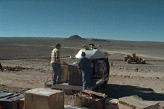
2.7.1 Objective
To demonstrate robotic technologies relevant to long-duration, long-distance planetary excursion and performance of remote geological experiments.
2.7.2 Approach
In June and July 1997, Carnegie Mellon University deployed the robot Nomad to traverse the Atacama Desert of Northern Chile. Nomad traveled an unprecedented 215 km in 45 days, controlled by visitors to the Carnegie Science Center in Pittsburgh, PA, and at one point, remotely driven from the laboratory at Ames. This NASA-funded research program tested technologies critical to planetary exploration and enabled scientists to perform remote geological experiments.
The robot traversing the Atacama desert was connected to the Science Center in Pittsburgh via satellite link. From there, data were transmitted over the NREN Sprint ATM network to ARC via the GSFC gateway. Requirements were for a continuous data rate of 1.54 Mbps - a high bandwidth link for images and low bandwidth radio for status/command/control. The NREN portion of the circuit allowed for flexible bandwidth allocation and easy routing of multicast traffic.
2.7.3 Accomplishments
NREN proved critical to the Nomad mission, since the project required a sustained bandwidth of 1.54 Mbps for a minimum of 12 continuous hours a day during the project's duration. Existing networks were unable to accommodate demands of this magnitude. The Nomad project is advancing the state-of-the-art in robot mechanisms, communication, imagery, and control and moves critical robotic technologies out of the laboratory and toward space. With capabilities forged in the desert, Nomad serves as the precursor to robotic explorers destined for distant planets.
2.7.4 Significance
Nomad validated the use of color stereo video cameras with human-eye resolution for geology. A separate panospheric camera (that takes a 360-degree picture) returned more than a million video panoramas from the Atacama desert, a cold, arid region located above 7,000 feet. The robot was configured to simulate wide-area exploration of the Moon, search for past life on Mars, and gather meteorite samples in the Antarctic. Aided by NREN's high performance network support, Nomad met or exceeded all of the objectives for the project. The robotic capabilities that Nomad demonstrated support NASA's missions of long-duration, long-distance planetary excursions and are extensible to other application domains and scalable to the future Internet.
2.7.5 Status/Plans
The Nomad Atacama Desert project was successfully completed. Future tests of the robot are expected to take place in Greenland and Antarctica.
2.7.6 Points of Contact and Relevant URLs
John Griffin, NREN Applications Manager, NASA Ames Research Center, 650-604-5447
3. NREN Accomplishments reported under the Earth and Space Sciences (ESS) Project
4. REFERENCES
NASA Research and Education Network/Next Generation Internet (NREN/NGI)
Telemedicine (Echocardiography)
Real-Time, Interactive Echocardiography Over Wide Area Networks
Advanced Aerospace Design
Distributed Image Spreadsheet - Earth Observing System
Virtual Simulation Laboratory
Virtual Reality on Mars Pathfinder
Nomad Rover at Atacama Desert, Chile