Space Imaging
The Earth from Above:
An Astronaut's View of the Planet
When the astronauts are in orbit, they have many duties to perform. But they also need some free time to rest and relax. What do you think astronauts do during rest periods while they're in space?
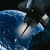
 The astronauts were once asked if they would like a television on board the shuttle. Their answer was a resounding, "No thanks!" They had a far more impressive spectacle to watch: the big blue planet Earth beneath them.
 In orbit, the shuttle flies at a remarkable speed: 28 000 km/h (about 17 400 mph). Since the Earth's circumference is about 40 000 km (24 850 miles), the shuttle is able to fly all the way around the planet in about an hour and a half.
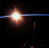 This means that every 90 minutes, the astronauts are able see the sun rise and set beyond the curving horizon of the planet. They experience 16 "days" in orbit for every one we have on Earth!
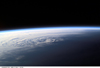
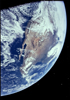 Because of the shuttle's incredible orbiting speed, the world appears to the astronauts above like a slowly spinning globe. In one 90-minute span, they see entire continents and oceans rush past beneath them. They are able to view the Earth as a whole, not just a random collection of countries.
|
From space, astronauts can watch entire weather systems work their way across the oceans.
|

|
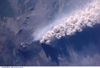
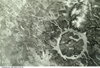
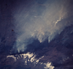
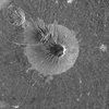
They can monitor erupting volcanoes...
|
|
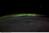
...or the aurora australis (southern lights).
|
They can learn about our planet's ancient past.
|
And they can observe the impact that human activity has on the environment, both locally and on a global scale.
|
|
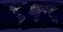
Indeed, when astronauts look down on the Earth from space, they are struck by how obvious and widespread human impact on the planet really is.
|
From space, astronauts are able to see cities, roads, and farmland...

|
...large, human-made structures such as the Great Pyramid of Khufu in Egypt...
|
...the effects of clearcut logging in the world's forests...
|
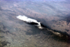
...even large sailing vessels on the water--and sometimes the oil slicks they leave behind.
|
Remote Sensing Images
Every time a shuttle is sent into orbit, its special camera systems take thousands of pictures of the planet for scientists to study back on Earth.
These photos are called "remote sensing images." That's because they are taken by cameras that are in orbit, far from the objects they are photographing.
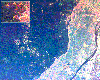
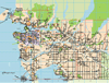
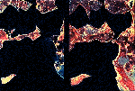
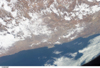
The information we get from remote sensing images is very different than what we get from regular maps. Take a look at these two different images of coastal British Columbia. How do the two types of visual information compare?

|
|
As you can see, the remote sensing image shows us the shape and location of mountains and valleys, roads, bridges, agricultural lands, and cities. We can also observe current weather systems in the area.
By looking at the mountains and valleys, we can imagine the path taken by glaciers as they carved their way through the rock thousands of years ago.
The road map, on the other hand, tells us the latitude and longitude of various places. It also tells us the names of places--such as cities, streets, and islands--and the distance between different places on the map.
The road map is more useful when we want to travel through an area. This map helps us figure out where we are and how to get from one place to another.
The remote sensing image, on the other hand, is more useful for observing changes in the atmosphere and landscape.
Remote sensing images are valuable tools for tracking pollution and monitoring the habitats of endangered species. They can also show us the effects of agriculture on our planet.
|
Depending on the kind of camera used, remote sensing images can also measure the heat of the planet and show us where underground thermal activity is taking place. This helps scientists learn more about the behaviour of volcanoes and earthquakes.
|
|
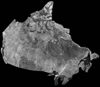
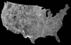
Remote sensing images have also been used to create large, mosaic images of entire countries. These mosaics can be used as a "baseline" against which future changes in climate, city size, and desert size can be measured.
|
|
Mapping the Planet
When the space shuttle Endeavour took to the skies in February, 2000, its crew was assigned a special mapping mission.
|
Over the course of 11 days, the shuttle's crew worked around the clock to take thousands of pictures with a special radar camera. The goal of the mission was to create the world's most detailed topographical map.
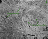
Topographical maps are also called three-dimensional maps. That's because they represent the elevations of geographic features such as mountains and valleys. Taken with a powerful radar camera, images from space can show such features in great detail.
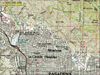
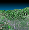
Compare the traditional topographical map of Pasadena, California (below left) with the radar-topography image created from data taken by the shuttle Endeavour (below right) and other sources. What do you think are the strengths and weaknesses of the two kinds of images?
|
|
The camera aboard Endeavour wasn't the kind of camera you would use to take snapshots of your friends. It weighed about 11 700 kilograms (25 800 pounds)!
Learn more about the Shuttle Radar Topography Mission.
How Well Do You Know Your Geography?
Before being able to "read" remote sensing images, it helps to be able to identify the geographic features they show.
See how well you can do. Try to match each definition with the appropriate image in the space imaging activity.