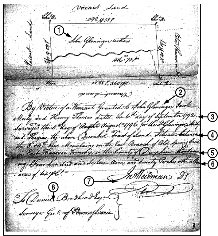
1. Plat map
 
2. Name of grantee
 
3. Date of warrant, date of survey
 
4. Description of the land
 
5. Location of the land
 
6. Number of acres
 
7. Surveyor's signature
 
8. State surveyor's name
 

Survey with Plat Map
from Dauphin County, Pennsylvania


Survey


Every state has, or had, large quantities of "surplus" public lands that it uses to generate revenue. Most states also had some provisions for giving land away to induce settlement or to reward veterans.
When an ancestor received a warrant authorizing a land grant, he was required to have the land surveyed by an authorized surveyor before the land could be granted. The surveyor surveyed the land and recorded it as a plat map, a copy of which was recorded in the state or county plat books or surveyor's records.
Most surveyor's records have not been abstracted or published. And, many plat books or surveyors' records have not been indexed.
Most state plat books and many county plat books have been microfilmed, and can be found at the LDS Family History Library and Family History Centers. Some collections of private, public, and university libraries may have microfilmed copies of local plat books.
Original plat books and surveyors' records are maintained by the state land offce or archives, or can be found in the town or county courthouse. Contact the town or county courthouse for information about what restrictions, if any, apply to in person research.
Some local historical societies or university libraries have the personal papers of local surveyors in their collections. Contact the appropriate historical society for more information.


© Palladium Interactive, Inc. 1997.
Go back to main menu Go to the index Go to the glossary Go to the top of the section Go to the top of the section