|
Page
31
|
Ground
Water
In the
desert country of eastern Idaho, people have generally placed a value on irrigation
water close to the level of motherhood, apple pie, and Family Home Evening.
Although most irrigation water today is provided from surface sources and wells,
many an early homestead was located next to a spring.
Ground water issues forth in springs where the water table intersects the land surface. In most cases these springs contain water that has fallen upslope, been absorbed into the ground, and spent a few weeks to thousands of years traveling to the point of issue.
Hot
Springs
Hot springs are present
across southern Idaho in diverse geologic settings on both sides of the Snake
River Plain. Generally, these springs are produced by the very slow circulation
of meteoric (rain) water to depths of 8,000 to 10,000 feet where it is heated
to near 80�C (ralston and others, 1980; 1983). These waters then recirculate
to the surface as hot springs. Studies from oil wells drilled in the 1970s reveal
that the geothermal gradient in southeast Idaho is generally high, ranging from
19 to 61�C per kilometer depth, with an average near 40�C/km. The average geothermal
gradient for the global continental crust is 26�C/km.
The residence times of waters in these systems (the time between the water falling as rain and it emerging from a hot spring) is surprisingly long: in most places in southeast Idaho it is over 25,000 years for hot springs over 25�C.
|
Snake River Plain
Aquifer, showing directions of flow and locations of outlets at the Thousand
Springs area northwest of Twin Falls. |
The Snake River aquifer is a complex system, with multiple layers of high permeability. It discharges 8 million acre feet of water per year in the famous Thousand Springs area on the north wall of the Snake River canyon from Twin Falls to Hagerman. Most of the commercially produced trout in the United States are grown there.
The Snake River Plain is underlain by fractured and rubbly basalt lava flows, which form a highly permeable aquifer. Interbeds between the basalt layers are mainly sand, silt and clay, with smaller amounts of volcanic ash. Within basalts, permeable zones are mainly the tops and bottoms of lava flows, with columnar jointing in between providing slower vertical transmission of water. Rhyolite that underlies the basalt does not have high permeability, as many of the pore spaces are filled with chemical precipitates.
Water which falls mainly as snow in the mountains north and east of the eastern Snake River Plain is absorbed into the basalt in many places along the northern margin of the plain. The most obvious is the Sinks of the Big Lost River east of Howe, where waters of the Big and Little Lost Rivers, and Birch Creek sink into the lava plateau.
 |
| Dams
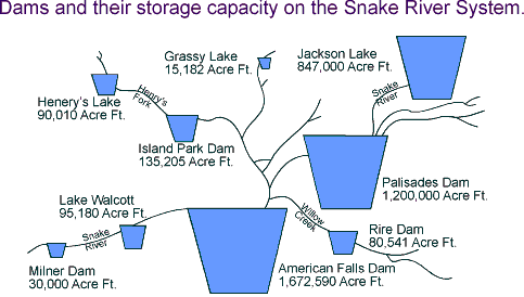
and their storage on the Snake River system. Source: U.S. Bureau of Reclamation |
Irrigation
and its Effect on the Snake River Plain Aquifer
Dams were put
on the Snake River at Milner, Minidoka, and American Falls in
the early 1900s. The extensive irrigation essentially recycles the Snake River
water, drawing it out of the river, and returning it to the river or the aquifer
downstream. When the amount of irrigation on the Snake River Plain is reduced,
output from the springs goes down also. The level of the aquifer rose dramatically
after initiation of irrigation, but the level stabilized after a new equilibrium
was reached. In the last 25 years, the level has begun to fall slowly.
Fundamentally, the Snake River Plain Aquifer is so large, with so much water running through it, and with residence times on the order of 100s of years, that it will be hard for man's efforts to change it much. Point sources of pollution certainly exist, but the dilution factor prevents them from becoming regional problems.
Water quality of the Snake River Plain aquifer is adversely affected by several human activities, most importantly agriculture. Runoff from fertilizer, feedlots, and potato processing plants has produced local acute pollution of the aquifer.
Another potential source of pollution is the Idaho National Engineering Laboratory. Voluminous and expensive monitoring programs are being conducted to determine the extent of INEEL-caused pollution. The bottom line appears to be that the dry climate on the Snake River Plain combined with the huge volume of water in the Snake River Plain aquifer act to limit the amount of radionuclides that have reached the aquifer and then to dilute them below detection limits.