|
Page
87
|


|
||
 |
||
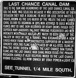
| Last Chance Canal Dam historical marker, (august, 1991). | ||
 |
||
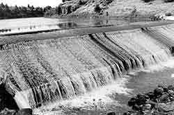
| Spillway of Last Chance Canal Company dam northeast of Grace, (august, 1991). Dam was built in 1904. | ||
 |
||
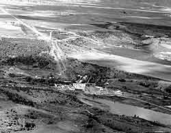
| Aerial view looking east at the Utah Power and Light power plant on the Bear River west of Grace. The penstock and pressure relief tower are at the top of the hill, about 300 feet above the elevation of the plant at the river's edge. The town of Grace is in the background, (May, 1992). |
Grace
Power Plant
In 1906,
L.L. Nunn and his Telluride Power Company moved in from Colorado and began construction
of the a major hydroelectric plant on the Bear River, taking advantage of the
500 foot drop in the elevation of the Bear River between Sheep Point and the
floor of the canyon west of Grace. In 1908, they finished a dam north of Grace
above the elevation of the Lake Bonneville shoreline, with the power plant a
few miles down the valley and 525 feet lower, on what had been the lake floor.
At that time the plant was the largest hydroelectric station west of Omaha.
At first the electricity was for use in the mining districts of Bingham, Utah
and Eureka, Nevada; it was not sold to local customers.
The Telluride Power Company eventually became the Utah Power and Light Company. In 1915, the Grace plant was the biggest station on the newly integrated Utah Power and Light system.
Lake
Thatcher and the Gem Valley Volcanic Field
Bear
River makes nearly a 180� bend around Soda Point and runs south into southern
Gem Valley and Cache Valley (mabey, 1979). However, as hypothesized in the 1963
Ph.D. dissertation of geologist Robert C. Bright, a native of Preston, the river's
course prior to about a million years ago was probably north to near Chesterfield
and then down the present Portneuf River canyon past Lava Hot Springs and to
the Snake River west of Pocatello. At this time, Gem Valley drained to the north,
much as Bear Lake Valley does today.
At times in the last million years the outlet of the ancestral Bear River became dammed and a lake, named Lake Thatcher, formed in Gem Valley. Volcanic activity of the Gem Valley volcanic field produced basalt lava flows which filled the north end of the valley, damming up the former Bear River course and forcing the river to turn south. The highest shoreline of Lake Thatcher was established at about 5445 feet elevation, after the lake was restricted to the southern part of the valley. Sediments deposited in Lake Thatcher underlie the farming country south of Grace and are recognized in water wells drilled as far north as Chesterfield. At its thickest point the Thatcher Formation is about 590 feet thick.
Some lava flows in northern Gem Valley were sourced from the Blackfoot lava field to the east. The lava flowed westward over the Chesterfield Range through Ten Mile Pass. Other main sources for lava flows were a fissure system that runs along the east side of the Gem Valley. The largest known lava tube is now an ice cave about 800 feet east of the cinder cone at Niter, south of Grace. About 600,000 years ago two basalt lava flows from northern Gem Valley ran down the course of the Portneuf River to Pocatello to form the Basalt of Portneuf Valley.
After Lake Thatcher occupied southern Gem Valley for perhaps several hundred thousand years, the Bear River drainage was captured, in Oneida Narrows, by south-flowing tributaries to Strawberry Creek and the Lake Bonneville basin. After Lake Thatcher drained southward into Cache Valley, the input of water from the Bear River plus a time of generally greater precipitation (a pluvial interval), caused Lake Bonneville to grow in the Great Salt Lake basin. The high level of Lake Bonneville,about 5,140 feet, reached into Gem Valley about 20,000 to 14,500 years ago. The shoreline was located just south of the site of the Grace Power Plant.