of97470i/europe
of97470i/europe/arcmap
ESRI ArcMap projects, data, documentation and ancillary files
|
Directories |
Files |
 |
data.htm
geo4_2.mxd prv4_2.mxd
|
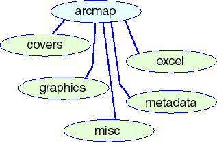
Directories
| covers | Arc/Info coverages used in creating maps
To view browse graphics of spatial data, go to supplementary spatial data |
| excel | Microsoft excel tables used in creating charts |
| graphics | Index map image used on maps |
| metadata | Documentation for Arc/Info coverages |
| misc | Ancillary files used in creating maps |
Files
| data.htm | Supplementary spatial data directory describing spatial data files used in creating the maps |
| geo4_2.mxd | ArcMap project used in creating Map Showing Geology, Geologic Provinces, and Oil and Gas Fields of Europe including Turkey |
| prv4_2.mxd | ArcMap project used in creating Map Showing Geologic Provinces, and Oil and Gas Fields of Europe including Turkey |
Arc/Info coverages used in creating maps
Click here to view Supplementary Spatial Data Directory
Click on coverage name to view browse graphic and link to metadata
| bath4_2 | Bathymetric depth contours of waters adjacent to Europe including Turkey |
| city4_2 | Selected cities in Europe including Turkey |
| eur4_2 | Political entities of Europe including Turkey |
| fld4_2 | Oil and gas field centerpoints of Europe including Turkey |
| flt4_2 | Faults of Europe including Turkey |
| geo_sval | Geologic age of Svalbard |
| geo4_2 | Geologic age of Europe including Turkey |
| grd4_2 | Latitude and longitude grid (2x2 degrees) of Europe including Turkey |
| info | Directory with INFO files |
| pol4_2 | Political boundaries of Europe including Turkey |
| prv4_2 | Geologic provinces of Europe including Turkey |
Microsoft excel tables with data used to create charts on Map Showing Geologic Provinces, and Oil and Gas Fields of Europe including Turkey
Files
| data.doc | Data dictionary of tables in this directory |
| gas.xls | Gas endowment of assessed provinces in Europe including Turkey |
| ngl.xls | Natural Gas Liquids endowment of assessed provinces in Europe including Turkey |
| oil.xls | Oil endowment of assessed provinces in Europe including Turkey |
| petro.xls | Petroleum endowment of assessed provinces in Europe including Turkey |
of97470i/europe/arcmap/graphics
Index map image used in creating maps
Files
| index1.JPG | Index map image used in creating maps |
of97470i/europe/arcmap/metadata
Documentation for Arc/Info coverages used to create maps
|
Directories |
Files |
 |
data.htm
|
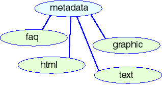
Directories
| faq | Metadata files in FAQ (Frequently Anticipated Questions) HTML format |
| graphic | Browse graphic files depicting Arc/Info coverages |
| html | Metadata files in HTML format |
| text | Metadata files in Windows text format |
Files
| data.htm | Spatial Data Directory describing documented spatial data |
of97470i/europe/arcmap/metadata/faq
Frequently Asked Question (FAQ) format HTML metadata files describing the coverages used in creating the maps
Click here to view Supplementary Spatial Data Directory
Files
Click on file name to view metadata file
| bath4_2f.htm | FAQ metadata file describing bathymetric contour coverage |
| city4_2f.htm | FAQ metadata file describing selected cities coverage |
| eur4_2f.htm | FAQ metadata file describing political entities coverage |
| fld4_2f.htm | FAQ metadata file describing oil and gas field centerpoints coverage |
| flt4_2f.htm | FAQ metadata file describing faults coverage |
| geo_sval.htm | FAQ metadata file describing Svalbard geology coverage |
| geo4_2f.htm | FAQ metadata file describing geology coverage |
| grd4_2f.htm | FAQ metadata file describing latitude-longitude grid coverage |
| pol4_2f.htm | FAQ metadata file describing political boundary coverage |
| prv4_2f.htm | FAQ metadata file describing geologic province coverage |
of97470i/europe/arcmap/metadata/graphic
Click here to view Supplementary Spatial Data Directory
Browse graphic files of coverages used to create the maps and HTML files
Files
| bath4_2f.gif | Graphic file describing bathymetric contour coverage; GIF format |
| city4_2f.gif | Graphic file describing selected cities coverage; GIF format |
| eur4_2f.gif | Graphic file describing political entities coverage; GIF format |
| fld4_2f.gif | Graphic file describing oil and gas field centerpoints coverage; GIF format |
| flt4_2f.gif | Graphic file describing faults coverage; GIF format |
| geo_sval.gif | Graphic file describing Svalbard geology coverage; GIF format |
| geo4_2f.gif | Graphic file describing geology coverage; GIF format |
| grd4_2f.gif | Graphic file describing latitude-longitude grid coverage; GIF format |
| pol4_2f.gif | Graphic file describing political boundary coverage; GIF format |
| prv4_2f.gif | Graphic file describing geologic province coverage; GIF format |
of97470i/europe/arcmap/metadata/html
HTML metadata files describing the coverages used in creating the maps
Click here to view Supplementary Spatial Data Directory
Files
Click on file name to view metadata file
| bath4_2.htm | HTML metadata file describing bathymetric contour coverage |
| city4_2.htm | HTML metadata file describing selected cities coverage |
| eur4_2.htm | HTML metadata file describing political entities coverage |
| fld4_2.htm | HTML metadata file describing oil and gas field centerpoints coverage |
| flt4_2.htm | HTML metadata file describing faults coverage |
| geo_sval.htm | HTML metadata file describing Svalbard geology coverage |
| geo4_2.htm | HTML metadata file describing geology coverage |
| grd4_2.htm | HTML metadata file describing latitude-longitude grid coverage |
| pol4_2.htm | HTML metadata file describing political boundary coverage |
| prv4_2.htm | HTML metadata file describing geologic province coverage |
of97470i/europe/arcmap/metadata/text
Windows text metadata files describing the coverages used in creating the maps
Click here to view Supplementary Spatial Data Directory
Files
| bath4_2.txt | Windows text metadata file describing bathymetric contour coverage |
| city4_2.txt | Windows text metadata file describing selected cities coverage |
| eur4_2.txt | Windows text metadata file describing political entities coverage |
| fld4_2.txt | Windows text metadata file describing oil and gas field center points coverage |
| flt4_2.txt | Windows text metadata file describing faults coverage |
| geo_sval.txt | Windows text metadata file describing Svalbard geology coverage |
| geo4_2.txt | Windows text metadata file describing geology coverage |
| grd4_2.txt | Windows text metadata file describing latitude-longitude grid coverage |
| pol4_2.txt | Windows text metadata file describing political boundary coverage |
| prv4_2.txt | Windows text metadata file describing geologic province coverage |
Symbolset, font and ancillary files used in creating the maps
Files
| geo4_2.style | ArcMap style file containing symbols used in creating maps |
| GEOAGE_.ttf | Univers style true type font containing geologic age symbols |
| sea.dbf | Attribute table for shapefile containing shoreline used in province map |
| sea.shp | Shoreline shapefile used in province map |
| sea.shx | Index file for shapefile containing shoreline used in province map |
| svalgrid.dbf | Attribute table for shapefile containing latitude-longitude grid for Svalbard insert in geology map |
| svalgrid.shp | Latitude-longitude grid shapefile used in Svalbard insert in geology map |
| svalgrid.shx | Index file for shapefile containing latitude-longitude grid for Svalbard insert in geology map |
ArcExplorer projects, data, documentation and ArcExplorer installation program
|
Directories |
Files |
 |
data.htm
geo4_2.aep
|
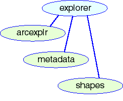
Directories
| arcexplr | Installation program and documents for ArcExplorer 1.1 |
| metadata | Documentation for shapefiles used in ArcExplorer project |
| shapes | Shapefiles used in ArcExplorer project |
Files
| data.htm | Spatial Data Directory describing shapefiles used in ArcExplorer project |
| geo4_2.aep | ArcExplorer project depicting geology and geologic provinces of Europe including Turkey |
of97470i/europe/explorer/arcexplr
Installation program and documents for ArcExplorer 1.1
Files
| ae2setup.exe | ESRI ArcExplorer installation program (Windows only) |
of97470i/europe/explorer/metadata
Documentation for shapefiles used in ArcExplorer project
|
Directories |
Files |
 |
|
Directories
| faq | Metadata files in FAQ (Frequently Anticipated Questions) HTML format |
| graphic | Browse graphic files depicting shapefiles |
| html | Metadata files in HTML format |
| text | Metadata files in Windows text format |
Click here to view Spatial Data Directory with browse graphics of spatial data sets published here
of97470i/europe/explorer/metadata/faq
Frequently Asked Question (FAQ) format HTML metadata files describing the shapefiles used in the ArcExplorer project
Files
Click on file name to view metadata file
| flt4_2gf.htm | FAQ metadata file describing faults shapefile |
| geo4_2gf.htm | FAQ metadata file describing geology shapefile |
| wep_prvg.htm |
FAQ metadata file describing geologic province shapefile |
of97470i/europe/explorer/metadata/graphic
Browse graphic files of shapefiles used in the ArcExplorer project
Files
| flt4_2g.gif | Browse graphic of faults shapefile (GIF format) |
| geo4_2g.gif | Browse graphic of geology shapefile (GIF format) |
| wep_prvg.gif | Browse graphic of geologic provinces shapefile (GIF format) |
of97470i/europe/explorer/metadata/html
HTML metadata files describing the shapefiles used in the ArcExplorer project
Files
Click on file name to view metadata file
| flt4_2g.htm | HTML metadata file describing faults shapefile |
| geo4_2g.htm | HTML metadata file describing geology shapefile |
| wep_prvg.htm | HTML metadata file describing geologic provinces shapefile |
of97470i/europe/explorer/metadata/text
Windows text metadata files describing the shapefiles used in the ArcExplorer project
Files
| flt4_2g.txt | Windows text metadata file describing faults shapefile |
| geo4_2g.txt | Windows text metadata file describing geology shapefile |
| wep_prvg.txt | Windows text metadata file describing geologic provinces shapefile |
of97470i/europe/explorer/shapes
Shapefiles used in the ArcExplorer project
Files
| flt4_2g.shp | Faults of Europe including Turkey shapefile (unprojected "geographic" latitude and longitude coordinates) |
| geo4_2g.shp | Geology of Europe including Turkey shapefile (unprojected "geographic" latitude and longitude coordinates) |
| wep_prvg.shp | U.S.G.S. World Energy Project geologic provinces of the world
(unprojected "geographic" latitude and longitude coordinates) |
Digital spatial data in Arc/Info export format, ascii text format and Spatial Data Transfer Standard (SDTS) formats
|
Directories |
Files |
 |
|
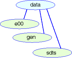
Directories
| e00 | Spatial data in ESRI Arc/Info export format (no compression) |
| gen | Spatial data in ESRI Arc/Info "generate" ascii text export format and attribute data in comma delimited text format |
| sdts | Spatial data in Spatial Data Transfer Standard (SDTS) format |
Click here to view Spatial Data Directory with browse graphics of spatial data sets published here
Spatial data in ESRI Arc/Info export format (no compression)
Files
| flt4_2g.e00 | Faults of Europe including Turkey |
| geo4_2g.e00 | Geology of Europe including Turkey |
| wep_prvg.e00 | U.S.G.S. World Energy Project geologic provinces of the world |
Spatial data in ESRI Arc/Info "generate" ascii text export format and attribute data in comma delimited text format
|
Directories |
Files |
 |
|
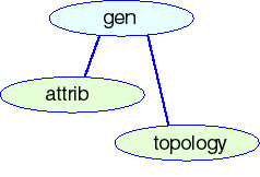
Directories
| attrib | Attribute data in comma delimited text format |
| topology | Topologic data in Arc/Info "generate" ascii text format |
of97470i/europe/data/gen/attrib
Attribute data in comma delimited text format
Files
| flt4_2g.csv | Faults of Europe including Turkey |
| geo4_2g.csv | Geology of Europe including Turkey |
| wep_prvg.csv | U.S.G.S. World Energy Project geologic provinces of the world |
of97470i/europe/data/gen/topology
Topologic data in Arc/Info "generate" ascii text format
Files
| flt4_2g.gen | Faults of Europe including Turkey |
| geo4_2g.gen | Geology of Europe including Turkey |
| wep_prvg.gen | U.S.G.S. World Energy Project geologic provinces of the world |
Spatial data in Spatial Data Transfer Standard (SDTS) format
Directories
| flt4_2g | Files comprising SDTS format export of faults of Europe including Turkey; with readme |
| geo4_2g | Files comprising SDTS format export of geology of Europe including Turkey; with readme |
| wep4_2g | Files comprising SDTS format export of U.S.G.S. geological provinces of the world; with readme |
HTML readme and data directory files with ancillary graphics files
|
Directories |
Files |
 |
europe.htm acroread.htm
|
Directories
| IMAGES | Ancillary graphics files for HTML readme and data directory files |
Files
| acroread.htm | HTML data directory of ACROREAD directory |
| europe.htm | HTML data directory of europe directory |
Ancillary graphics files for HTML readme and directory files
Files
| ACROREAD.gif | Diagram of ACROREAD directory |
| arcmap.gif | Diagram of arcmap directory |
| covlogo.JPG | U.S.G.S. graphic logo |
| data.gif | Diagram of data directory |
| europe.gif | Diagram of europe directory |
| explorer.gif | Diagram of explorer directory |
| gen.gif | Diagram of gen directory |
| html.gif | Diagram of html directory |
| metadata.gif | Diagram of metadata directory |
| root.GIF | Diagram of CD-ROM root |
| views.gif | Diagram of views directory |
Documentation for spatial data published on this CD-ROM
|
Directories |
Files |
 |
data.htm |
Directories
| faq | Metadata files in FAQ (Frequently Anticipated Questions) HTML format |
| graphic | Browse graphic files depicting shapefiles |
| html | Metadata files in HTML format |
| text | Metadata files in Windows text format |
Click here to view Spatial Data Directory with browse graphics of spatial data sets published here
Frequently Asked Question (FAQ) format HTML metadata files describing the spatial data published on this CD-ROM creating the maps
Files
Click on file name to view metadata file
| flt4_2gf.htm | FAQ metadata file describing faults spatial data |
| geo4_2gf.htm | FAQ metadata file describing geology spatial data |
| wep_prvg.htm | FAQ metadata file describing geologic province spatial data |
of97470i/europe/metadata/graphic
Browse graphic files of spatial data published on this CD-ROM
Files
| flt4_2g.gif | Browse graphic of faults spatial data (GIF format) |
| geo4_2g.gif | Browse graphic of geology spatial data (GIF format) |
| wep_prvg.gif | Browse graphic of geologic provinces spatial data (GIF format) |
HTML metadata files describing the spatial data published on this CD-ROM
Files
Click on file name to view metadata file
| flt4_2g.htm | HTML metadata file describing faults spatial data |
| geo4_2g.htm | HTML metadata file describing geology spatial data |
| wep_prvg.htm | HTML metadata file describing geologic province spatial data |
Windows text metadata files describing the spatial data published on this CD-ROM
Files
| flt4_2g.txt | Windows text metadata file describing faults spatial data |
| geo4_2g.txt | Windows text metadata file describing geology spatial data |
| wep_prvg.txt | Windows text metadata file describing geologic province spatial data |
of97470i/europe/PERMSSN
Graphic facsimiles of permission to publish proprietary data and software on this CD-ROM
Files
| ARCEXPL.TIF | Facsimile of permission from Environmental Systems Research Institute, Inc (ESRI) to distribute ArcExplorer software; TIFF format |
| ATTACH_B.TXT | Esri data license agreement ruling ESRI data included on this disk |
| CGMW.TIF | Facsimile of permission from the Commission for the Geological Map of the World (CGMW) to use sources in the compilation of these maps; TIFF format |
| PIDC.TIF | Facsimile of permission from Petroconsultants International Data Corporation to use oil and gas field centerpoints on this maps; GIF format |
| UNESCO.tif | Facsimile of permission from the United Nations Educational, Scientific and Cultural Organisation (UNESCO) to use sources in the compilation of these maps; GIF format |
Graphic files for plotting MAP SHOWING GEOLOGY, GEOLOGIC PROVINCES, AND OIL AND GAS FIELDS OF EUROPE INCLUDING TURKEY and MAP SHOWING GEOLOGIC PROVINCES, AND OIL AND GAS FIELDS OF EUROPE INCLUDING TURKEY
Files
| geo4_2.ps | Postscript plot file of geology map of Europe including Turkey |
| prv4_2.ps | Postscript plot file of geologic province map of Europe including Turkey |
Arcview projects presenting data published on this CD-ROM, data, documentation and ancillary files
|
Directories |
Files |
 |
data.htm
geo4_2.apr g4_2_win.apr
|
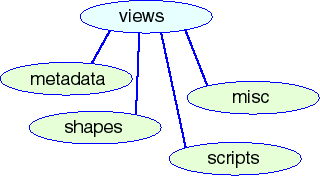
Directories
| metadata | Documentation for shapefiles used in Arcview projects |
| misc | Symbolsets and ancillary files used in Arcview projects |
| scripts | Avenue scripts modifying Arcview projects |
| shapes | Shapefiles used in Arcview projects |
Files
| data.htm | Spatial Data Directory describing shapefiles used in ArcExplorer project |
| geo4_2.apr | Arcview project depicting geology and geologic provinces of Europe and
Turkey
General version viewable on any computer installed with Arcview v3.x (Modification of system files required; see Readme for explanation) |
| g4_2_win.apr | Arcview project depicting geology and geologic provinces of Europe and
Turkey
Version viewable on any Windows 95/NT/2000 computer installed with Arcview 3.x (No modification required) |
of97470i/europe/views/metadata
Documentation for shapefiles used in Arcview projects
|
Directories |
Files |
 |
|
Directories
| faq | Metadata files in FAQ (Frequently Anticipated Questions) HTML format |
| graphic | Browse graphic files depicting shapefiles |
| html | Metadata files in HTML format |
| text | Metadata files in Windows text format |
Click here to view Spatial Data Directory with browse graphics of spatial data sets published here
of97470i/europe/views/metadata/faq
Frequently Asked Question (FAQ) format HTML metadata files describing the shapefiles used in the Arcview projects
Files
Click on file name to view metadata file
| flt4_2gf.htm | FAQ metadata file describing faults shapefile |
| geo4_2gf.htm | FAQ metadata file describing geology shapefile |
| wep_prvg.htm | FAQ metadata file describing geologic province shapefile |
of97470i/europe/views/metadata/graphic
Browse graphic files of shapefiles used the Arcview projects
Files
| flt4_2g.gif | Browse graphic of faults shapefile (GIF format) |
| geo4_2g.gif | Browse graphic of geology shapefile (GIF format) |
| wep_prvg.gif | Browse graphic of geologic provinces shapefile (GIF format) |
of97470i/europe/views/metadata/html
HTML metadata files describing the shapefiles used in the Arcview projects
Files
Click on file name to view metadata file
| flt4_2g.htm | HTML metadata file describing faults shapefile |
| geo4_2g.htm | HTML metadata file describing geology shapefile |
| wep_prvg.htm | HTML metadata file describing geologic provinces shapefile |
of97470i/europe/views/metadata/text
Windows text metadata files describing the shapefiles used in the Arcview projects
Files
| flt4_2g.txt | Windows text metadata file describing faults shapefile |
| geo4_2g.txt | Windows text metadata file describing geology shapefile |
| wep_prvg.txt | Windows text metadata file describing geologic provinces shapefile |
Symbolsets and ancillary files used in the Arcview projects
Files
| faults.avl | Legend file for drawing faults |
| geo4_2.avl | Legend file for drawing geologic age |
| reg4shd.avp | Palette file with geologic age colors |
| geofill.avp | Palette file with rock type (Volcanic and Intrusive Igneous rocks, and Metamorphic rocks) fill patterns |
Shapefiles used in Arcview projects
Files
| flt4_2g.shp | Faults of Europe including Turkey shapefile (unprojected "geographic" latitude and longitude coordinates) |
| geo4_2g.shp | Geology of Europe including Turkey shapefile (unprojected "geographic" latitude and longitude coordinates) |
| wep_prvg.shp | U.S.G.S. World Energy Project geologic provinces of the world
(unprojected "geographic" latitude and longitude coordinates) |
Click here to view Spatial Data Directory with browse graphics of spatial data sets published here
Avenue scripts modifying Arcview projects
Files
| startup.ave | "Start up" file displaying project name |